


How to Find Where a Photo Was Taken: 12 ChatGPT and Gemini Prompts (2026)
Two ways to find where a photo was taken: read the GPS data on iPhone, Google Photos or Windows, or have Gemini and ChatGPT read the clues in the frame. 12 ready-to-use prompts, the results of Bellingcat's 52-photo test, and steps to hide the location of your own photos.
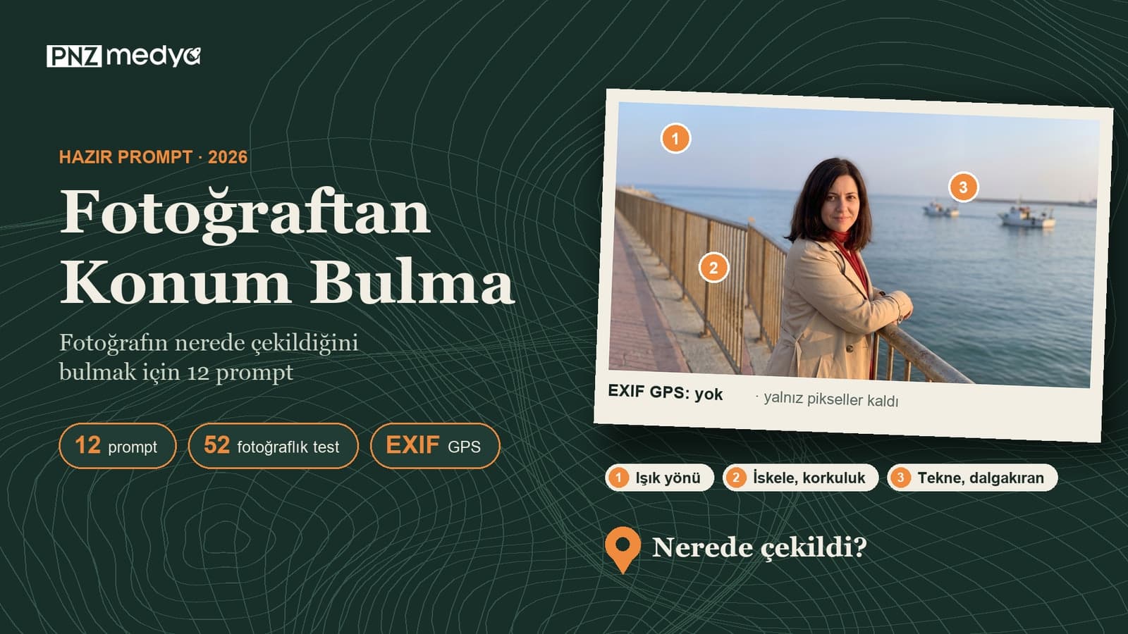
- Start with the file itself: a photo taken on a phone with location access turned on carries its coordinates inside. On iPhone, open the photo and swipe up; on Windows, the Properties > Details tab shows this record.
- If there's no record (a screenshot, an old photo, a copy someone sent you), Gemini and ChatGPT can work out candidate places from signs, license plates, plants, architecture and shadows in the frame. Below are 12 ready-to-use prompts for that.
- In Bellingcat's October 22, 2026 test, the best model (Gemini 4 Argon) placed 23 of 52 photos with their location data removed within 1 km, and 36 within 25 km. The same model was off by more than 25 km on 16 photos.
- Ask the AI for 3 candidates with reasons instead of one coordinate, and check the candidates yourself in Google Maps. Telling the same chat which candidate you ruled out narrows the guess (prompt 12).
- The same method works on your photos too. Before sharing on iPhone, turn off Share > Options > Location; use prompt 11 to find any sign or door number that gives your location away, then crop it out.
On October 22, 2026, Bellingcat gave 15 AI models 52 never-published photos with their location data removed and asked for a single coordinate for each. Gemini 4 Argon did best: it put 23 photos within 1 kilometer of where they were taken, and on 16 it was off by more than 25 kilometers. When you're trying to find where a photo was taken, AI narrows down the candidates fast. The final check is still yours.
Look at the file before you turn to AI. A photo taken on a phone with location access turned on stores the coordinates of where it was taken in a hidden data field called EXIF, and the phone's gallery shows them on a map. If there's no record, the 12 prompts below come in. The same clues work on the photos you share, too; the last section of this post is about hiding them.
We did not run the prompts in this post through a scored test in Gemini or ChatGPT. The accuracy figures come from the test Bellingcat published on October 22, 2026; we took the models' distance bands from the chart file Bellingcat published and counted them again. The iPhone, Mac and Google Photos steps come from Apple's and Google's Turkish help pages, and the legal information from the text of Law No. 7406; all were read on November 19, 2026.
How to Find Where a Photo Was Taken: Check the File's GPS Data First
Short answer: open the photo in your phone's gallery and go to the info screen. If there are coordinates, the map shows up right there and you're done. A screenshot, a copy with the record stripped, or a photo taken with location access turned off won't show a map; that's when you move on to the clues in the frame.
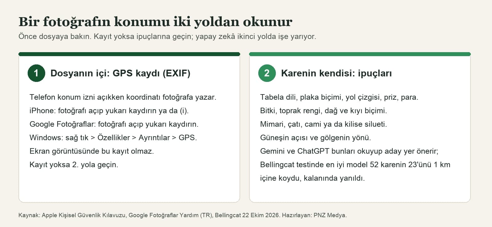
| Where | See the location | Remove or hide the location | Note |
|---|---|---|---|
| iPhone, iPad (Photos) | Open the photo and swipe up, or tap the (i) button | ••• > Adjust Info > Adjust Location > No Location | Collections > Map shows only photos with GPS data |
| Mac (Photos) | Select the photo and click the (i) button | Image > Location > Hide Location | Undo it with Revert to Original Location |
| Android (Google Photos) | Open the photo and swipe up | Edit > Remove location (only for estimated or manually added locations) | A location added by the camera can't be edited in Google Photos |
| Windows | Right-click the file > Properties > Details > GPS | Remove Properties and Personal Information, on the same tab | Reads the file itself, no app needed |
| Screenshot | No coordinates for where it was taken | - | Move on to the clues in the frame |
Google's help page has a detail that's easy to miss: Google Photos can add an estimated location to photos that have no record, based on landmarks in your other photos. You turn this off under Photos settings > Privacy > Location options > Estimate missing locations. A pin you see on the map may be an estimate instead of the camera's record.
How to Find a Photo's Location With AI: 5 Steps
If there's no record, you upload the photo to Gemini or ChatGPT and have it read the clues. In Bellingcat's first round in June 2025 (25 photos, 20 models), ChatGPT's o3 and o4-mini models beat Google Lens's visual match results by a small margin; by the October 2026 round, models had improved enough to identify a country and a park from vegetation.
- Check the gallery's info screen first. If coordinates show up, you don't need AI.
- Upload the largest version of the photo. You can crop out people; leave the background, the sky and the signs at the edges, because that's where the clues are.
- Ask the model for the clues first, then for 3 candidate places with reasons (prompts 1 and 3). Don't ask for a single coordinate.
- Open the candidates in Google Maps, Street View or Google Earth and match a detail from the frame (a pier, a minaret, a mountain outline).
- Tell the same chat which candidate you ruled out and why, and ask for a new guess (prompt 12).
Bellingcat deliberately asked the models for a single coordinate, and even the best model put its pin more than 25 km away on 16 of 52 photos. For your own use, ask for 3 candidates and a confidence level; that way the model tells you plainly where it isn't sure.
12 Ready-to-Use Prompts to Find Where a Photo Was Taken (Gemini and ChatGPT)
The prompts are written to work as-is in both Gemini and ChatGPT. Attach the photo to the chat, copy the prompt, and fill in the bracketed parts with what you know. Everything you add (the year, cities you visited, the season) shortens the list of candidates.
1) Find the location step by step: clues, candidates, confidence
Help me find where this photo was taken. The photo is mine, [e.g. I took it in the summer of 2019 but don't remember where].
First, list the clues you see in the frame one by one: signs and the language they're written in, license plates, road markings, plants, architecture, the shape of the coast or mountains, the direction of the sun.
Then rank the 3 most likely places. For each one, give the city or region name, the clues that lead you there, and your confidence (high, medium, low).
Don't invent any detail you're not sure of; if text can't be read, say "unreadable".
Don't try to identify the people in the photo.This is the starting prompt for most photos. Check the candidate with the lowest confidence on the map last.
2) Short version: which country, which city?
Which country and which city could this photo have been taken in? Give me a short list of the 3 most likely places, each with the clue it's based on.3) Clues only, no guessing yet
List everything in this photo that gives a clue about the location, but don't guess a place yet.
For each clue, write where it is in the frame (top left, center, etc.), what it is, and which regions it could point to.
If there's any text, copy it exactly, letter by letter; mark letters you can't read with [?].
At the end of the list, ask me what information you need from me to narrow down the guess.If the model jumps to a guess too early, it can get stuck on its first impression. When you ask for the clues separately first, you see which ones it relies on, and the [?] mark makes it visible when an unreadable sign gets filled in with a guess.
4) Narrow down the country: roads, plates, signs
I want to narrow down which country this photo was taken in.
Look at each of these separately and write which countries each one rules out: which side of the road vehicles drive on, license plate color and format, traffic signs, roadside posts, the language and alphabet on signs, utility poles.
Finally, list the remaining countries in order of likelihood.
Don't rule out a country based on a detail you didn't see.5) Vacation photo: cove, beach, coastline
This photo was taken near [e.g. a cove around Bodrum, Turkey] in the summer of [year]. I want to find out which cove, beach or stretch of coast it is.
Study the coastline, the islands or headland across the water, the color of the sand and rocks, the pier and the boats.
Give me 3 candidate places and, for each one, the exact search text I can type into Google Maps.
Also tell me which detail would settle it between two candidates.Asking for the search text makes the answer easy to check: paste it into Google Maps and compare the coastline in satellite view.
6) Old family photo: city, neighborhood and year
I'm trying to find which city and neighborhood this old family photo was taken in. What I know: [cities the family lived in, e.g. Cleveland and Chicago], [approximate year, e.g. the 1970s].
Study the buildings in the background, the shop signs, the car models, the clothing and the look of the street.
Give the year range first, then the candidate place; for both, write which detail you're basing it on.
Don't guess who the people in the photo are. Don't write the name of a shop or building you don't actually know.Old photos never have a location record, and the streets have changed. Writing down the cities the family lived in keeps the model from searching the whole world.
7) Nature shots: plants, soil and mountains
There are no buildings or signs in this photo, only nature. I want to find the region where it was taken from the vegetation and the landforms.
Describe the types of trees and shrubs, the color of the soil and rock, the shape of the mountains, and any signs of snow or drought; explain which climate and region each one fits.
Then suggest 3 regions and give a confidence level for each. Don't give a single coordinate; the region name is enough.One of the examples in Bellingcat's October 2026 test showed only plants and the corner of a roof; several models worked out Kenya and the park from the vegetation, while others put their pin far away.
8) Streets and buildings: architecture, signs, sidewalks
I want to find which city this street photo was taken in.
Study the architectural period of the buildings, the facade materials, the roof shapes, the balconies, the paving stones, the street lamps and every visible sign. Copy the text on the signs exactly.
Rank the 3 most likely cities or neighborhoods.
Give me a search text I can check in Google Maps Street View and the detail I should look for there.9) Verify a news or social media photo
People on social media say this photo shows [claimed place, e.g. downtown Houston] on [claimed date]. Help me verify the claim.
Make two lists: clues that match the claim and clues that contradict it. Look at the season, the weather, the language on the signs, the license plates, the architecture and the direction of the shadows.
At the end, say whether the claim is consistent, contradicted or unclear.
If you think the photo was taken somewhere else, name the candidate place separately; don't state it as certain.This is the most useful prompt for weeding out old photos that circulate during a disaster or a breaking event. A single contradicting clue (like green leaves in a shot supposedly taken in winter) is often enough.
10) Direction and time of day from the sun and shadows
Look at the direction of the shadows and the light in this photo and estimate which way the camera was facing and roughly what time of day it was taken.
I know the photo was taken around [date or season] near [city].
Show your reasoning step by step, state your assumptions, and give the result as a broad range such as morning, midday, afternoon or evening. Don't give an exact time.11) Before you share: does my photo give away my location?
I want to do a privacy check on this photo before I post it on social media.
List every detail in the frame that could reveal where my home, my workplace or my child's school is: house number, street sign, license plate, the view from the window, shop name, school logo.
For each detail, write where it is in the frame and how I can hide it (cropping, covering it with a solid color).
Don't edit the photo, just give me the list.This prompt turns the method around: you find the same clues before someone else does.
12) Narrow it down in the same chat
I checked [candidate 1], which you suggested, on Google Maps: [e.g. there's a pier, but the hill in the background isn't there].
I also ruled out [candidate 2] because [reason].
Update your guess with this information: tell me which clue you reinterpreted and give me 3 new candidates.
If you need a new clue, tell me which part of the photo I should zoom in on and upload again.Say in the first line that the photo is yours and that you don't want the people in it identified; cropping out the people and uploading only the background also works. Asking about the same photo again in a new chat gives you a second opinion: start with the candidate that comes up in both chats.
How Accurately Can AI Find Where a Photo Was Taken? A 52-Photo Test
In Bellingcat's October 2026 test, the photos had never been published online, their location data had been removed, and they contained no landmarks; some were taken in snow, fog or at night. The models could use their providers' search, code execution and page reading tools, and gave one coordinate per photo.
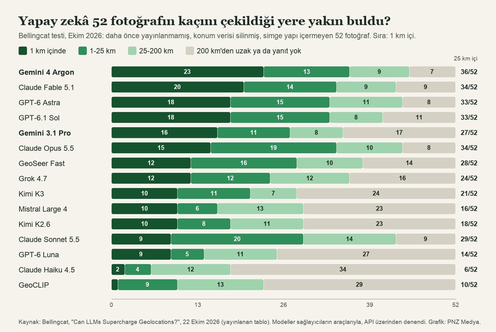
| Model | Within 1 km | Within 25 km | Median error | Average response time |
|---|---|---|---|---|
| Gemini 4 Argon | 23/52 | 36/52 | 1.7 km | 265 s |
| Claude Fable 5.1 | 20/52 | 34/52 | 4.7 km | 131 s |
| GPT-6.1 Sol | 18/52 | 33/52 | 3.5 km | 58 s |
| GPT-6 Astra | 18/52 | 33/52 | 6 km | 67 s |
| Gemini 3.1 Pro | 16/52 | 27/52 | 20.9 km | 217 s |
| Claude Opus 5.5 | 15/52 | 34/52 | 4.4 km | 26 s |
| Grok 4.7 | 12/52 | 24/52 | 44.6 km | 265 s |
| GeoCLIP (open model built for geolocation) | 1/52 | 10/52 | 355.4 km | 613 s |
Two things stand out in the table. First, the median error looks misleadingly small: Gemini 4 Argon's median is 1.7 km, yet the same model put its pin more than 25 km away on 16 of the 52 photos. Second, the gap between models from the same company is large: Gemini 3.1 Pro got 16 photos within 1 km, Argon got 23. Bellingcat tested the models through the API; which model runs in the Gemini and ChatGPT apps depends on your subscription plan.
AI models remain a useful assistant rather than a tool we can blindly delegate geolocations to.
In Bellingcat's own example, 11 of 17 models (counting the agents with extra tools) answered within 5 km for a photo taken in Venice; only two custom agents equipped with extra tools found the camera's exact spot. In everyday use, that means AI usually gets the city and the neighborhood right, and you confirm the street and the building on the map.
Common Mistakes
- Treating the single coordinate a model gives you as fact. Even the best model was off by more than 25 km on one photo in every three.
- Looking for GPS data in a screenshot or a re-saved copy. The record is usually in the original file; if you can, ask the person who took the photo for the original.
- Cropping out the background and uploading only the person. The location clues are in the sign at the edge, the mountain against the sky, the markings on the road.
- Assuming the model actually read an unreadable sign. A model can fill in missing letters with guesses; the [?] mark in prompt 3 exposes this.
- Assuming every photo on the Google Photos map carries the camera's record. If Estimate missing locations is on, the pin may be an estimate.
- Sharing your own photos with location data turned on. The method works both ways.
How to Hide the Location of Your Own Photos
Apple's Personal Safety User Guide says it plainly: "When photos and videos containing location metadata are shared, the people you share them with can access the location metadata and find out where they were taken" (our translation of the Turkish edition). There are three ways to turn location off:
- When sharing: on iPhone, select the photo, tap Share, then Options, and turn off Location. "Location Not Included" appears above the Options button.
- When shooting: Settings > Privacy & Security > Location Services > Camera > Never. From then on, no coordinates are written to new photos, and those photos don't appear in the Map collection.
- In a shared album in Google Photos: Share > Options, then turn off Share photo location. According to Google, location sharing is off by default in new conversations.
Even if you hide your photos' location from others, people may be able to estimate the location based on landmarks in your photo.
This warning from Google describes exactly what Bellingcat measured. Removing the coordinates cleans the file; the apartment building's name or the school logo in the frame stays. Use prompt 11 to find the details that give you away, then crop them or cover them with a solid color. We showed in a separate measurement how poorly blurring works on faces and text.
The Legal Line on Finding a Photo's Location in Turkey
In Turkey, location data counts as personal data under the definition in the Personal Data Protection Law No. 6698 (KVKK) if it can be linked to an identified or identifiable person. Finding where your own photo was taken, or verifying a news photo, stays inside that line. Working out someone's home, workplace or child's school from a photo they shared is a different matter.
Article 123/A, added to the Turkish Penal Code by Law No. 7406 in 2022, makes stalking a crime: causing someone serious distress by following them physically or by trying to contact them through information systems is punishable by six months to two years in prison. The penalty is higher if the victim is a child. That's why the prompts in this post leave identifying people out.
First open the photo in your gallery and look at the info screen: on iPhone, swipe up; on Windows, check Properties > Details > GPS. If there are no coordinates, upload the photo to Gemini or ChatGPT, ask for the clues and 3 candidate places with reasons, and check the candidates in Google Maps.
It usually finds the region, but it can't always find the exact spot. In Bellingcat's October 2026 test, the best model placed 23 of 52 photos with their location data removed within 1 km and 36 within 25 km; on 16 photos it was off by more than 25 km.
Reading the GPS data in the file is free on your phone and on Windows. You can also upload photos and use these prompts on the free plans of Gemini and ChatGPT; the model on a free plan may differ from the strongest models Bellingcat tested.
In the Photos app, open the photo and swipe up, or tap the (i) button; if there's a location record, a map appears. Collections > Map gathers every photo with GPS data on one map.
On iPhone, Settings > Privacy & Security > Location Services > Camera > Never stops location from being written to new photos. When sharing, turning off Share > Options > Location removes the coordinates for that share only.
In Turkey, a location is personal data under KVKK if it can be linked to a person. Using a location you found to persistently follow someone physically or through digital means and cause them distress is defined as the crime of stalking in Article 123/A of the Turkish Penal Code, with a prison sentence of six months to two years.
Before you share your next vacation photo, try prompt 11. If a door number or a building name shows up in the model's list, don't send that photo without cropping it.
AI Integration Services
We build AI workflows that read photos and documents into your business, such as systems that sort field photos or pull details from product images. Let's look at what you need in a free initial call.